
I am always surprised when some piece of information I’m looking for is actually not on the Internet. Such was the case this afternoon when I searched for a list of the largest endorheic waterbodies in the world. An endorheic waterbody is a terminal lake (sometimes called a sea) that has no outlet other than evaporation. In other words, rivers and streams flow in but nothing flows out. Since the only way water escapes is via evaporation everything else – salt, nutrients, pollution – are continuously concentrated in the remaining water. Some, like the Dead Sea, are so salty they cannot support life, but others support very unique ecosystems.
I’ve become interested in endorheic lakes because they are a microcosm for a number of water-related issues and act as a catchall for the pollution we put into our waterways. Take, for example, Devils Lake in North Dakota. Having no outlet means that the level of the lake can increase dramatically over a short period of time. Since 1995, water levels have gone up nearly 25 feet destroying hundreds of homes and businesses and inundating thousands of acres of productive farmland. State government constructed an outlet to release water into a nearby river but faced stern opposition from other states and Canada, who don’t want pollution and parasites from Devils Lake transferred into their waters. As you can see, it can become quite the predicament. Just wait until I get around to blogging about the Salton Sea!
Anyway, I was searching the Internet for a list of the largest endorheic lakes and I just couldn’t find one. Sure, Wikipedia has a list of the largest lakes in the world, but this only includes a handful of endorheic lakes. Wikipedia also has a page on endorheic basins, which mentions a lot of lakes but not in any structured way. It also intermingles them with drainage basins, which may capture water without outlet but are clearly not lakes. So, Internet, you’re welcome, because today I have constructed for you a list of the Top Ten Endorheic Lakes of the World (by surface area).
#10 South Aral Sea – Kazakhstan and Uzbekistan

Surface Area: 1,350 mi2 (3,496 km2)
 Volume: 21 mi3 (87 km3)
 Elevation: 95 ft (29 m)
 Depth: 131 ft (40 m)
Oh, how the mighty have fallen! The Aral Sea was once the fourth largest lake in the world; however, poor water resource management by the former Soviet Union (and continued by Russia) caused the Sea to decline to 10% of it’s original size and split in two over a period of just 50 years! The South Aral Sea was at first made up of east and west basins, but by 2009 the shallower east basin had evaporated completely, leaving just the west basin. The North Aral Sea is smaller but would be ranked #11 on this list.
Basically, in the 1960’s the USSR considered the Aral Sea a “mistake of nature” and diverted the two rivers that fed it to irrigation projects that would “green the desert.” Without a source of water the lake began to dry up, devastating the ecosystem as well as the economies of coastal fishing communities. The exposed bottomlands were so contaminated with pesticides and fertilizer from decades of agricultural runoff that toxic dust storms now blow over nearby towns causing cancer and lung disease.
Nevertheless, even at 10% of it’s original size, the remaining South Aral Sea is still large enough to make it into this top ten list – but for how much longer is unclear. The South Aral Sea is expected to be completely gone within 15 years.
#9 Lake Van – Turkey

Surface Area: 1,450 mi2 (3,755 km2)
 Volume: 146 mi3 (607 km3)
 Elevation: 5,380 ft (1,640 m)
 Depth: 1,480 ft (451 m)
The largest lake in Turkey became endorheic when lava flows cut off the lake’s outflow some 1-2 million years ago. As is common with terminal lakes, Lake Van is known for its dramatically fluctuating water levels. The lake level rose 10 feet in the 1990’s flooding much of the area’s agricultural land.
Because the lake has no outlet, undisturbed sediment continuously accumulates. Lake Van has a layer of sediment 1,300 feet thick and scientists who have retrieved cores from the lake floor have obtained climate data for the past 14,570 years.
The lake is so salty that only one fish, the Pearl Mullet, thrives in it – though there are also rumors of a sea monster named Van Gölü Canavarı.
#8 Great Salt Lake – Utah, USA

Surface Area: 1,700 mi2 (4,400 km2)
 Volume: 4.53 mi3 (18.91 km3)
 Elevation: 4,196 ft (1,279 m)
 Depth: 33 ft (10 m)
Located in the northern part of the Utah, it’s the largest salt lake in the western hemisphere. Like Lake Van the Great Salt Lake (GSL) is known for it’s dramatic fluctuations in water level. In this case, however, they are attributed to the overall shallowness of the waterbody. Unlike Lake Van, the GSL supports a diverse wildlife population. There are few fish, but the marshes surrounding the lake account for 75% of the wetlands in Utah and provide habitat for millions of migratory birds and waterfowl.
Recently it was discovered that methylmercury levels in the GSL are extremely high – 25 times higher than levels that trigger fish advisories in other parts of the country. Studies have shown that the cause is global industry and coal-burning power plants, which put mercury into the atmosphere. After drifting around the globe this mercury sometimes finds its way into rivers, oceans, and lakes. What makes the GSL different from other waterbodies is that the unique endorheic qualities of the lake have created a peculiar combination of bacteria and chemicals that convert inorganic mercury to its more harmful form, methylmercury.
If mercury poisoning doesn’t frighten you, there’s also the obligatory lake monster. Named the North Shore Monster by someone with no imagination, it is said to have the body of a crocodile and the head of a horse (thanks Wikipedia!).
#7 Qinghai Lake – China

Surface Area: 1,733 mi2 (4,489 km2)
 Volume: 20.39 mi3 (85 km3)
 Elevation: 10,476 ft (3,193 m)
 Depth: 617 ft (188 m)
Qinghai, the largest lake in China, lies in the Northeast of Qinghai Province. An alpine lake, it typically freezes over for three months in the winter. In summer it’s a popular destination for both tourists and birds. So many birds in fact that it is considered a focal point in global concerns over avian influenza (H5N1). The fear is that if infected birds make it to Qinghai Lake they will spread the disease to migratory birds capable of carrying it across Europe and Asia. Minor outbreaks have already been identified in the lake’s bird population.
Since the 1960’s, the lake has been shrinking due to reduced water inflow from major rivers and local farmers have turned large tracts of lakeside grassland into farmland. To reverse the situation, the Chinese government has returned 81,545 acres of farmland to pasture and set up three wetland monitoring stations.
The lake monster in Qinghai is, of course, a dragon.
#6 Lake Urmia – Iran

Surface Area: 2,000 mi2 (5,200 km2)
 Volume: 6.23 mi3 (26 km3)
 Elevation: 4,183 ft (1,275 m)
 Depth: 42 ft (13 m)
You probably won’t be surprised to learn that there’s not a lot of good information on this large salt lake located in Northwestern Iran (at least not in English). I can tell you that the dominant life form in the lake is the brine shrimp, much to the delight of local bird life. Because all rivers entering the lake receive more or less untreated waste from urban settlements along them, you might expect the lake to be highly polluted. But au contraire, it seems that bacteria and typhoid can’t survive in the highly saline waters. Score one more point for endorheic basins (and thanks International Journal of Salt Lake Research)!
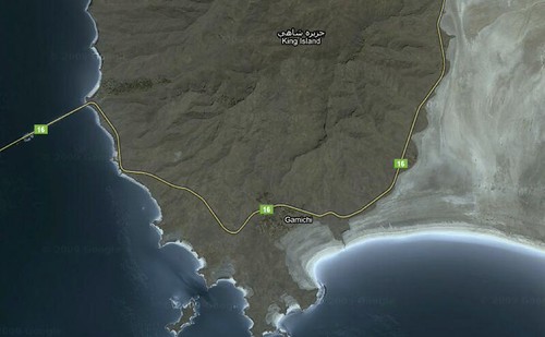
If Google Maps is anything to go by, it looks like Gamichi used to be a coastal town on King Island, but is now just an inland village no longer on an island. If water levels continue to fall the region will likely be plagued by monstrous storms of toxic dust blowing all the way to Tehran. It’s been reported that, as part of plans to restore the lake, Iranian government is starting a cloud-seeding program. Good luck with that one, guys!
#5 Issyk Kul – Kyrgystan

Surface Area: 2,407 mi2 (6,236 km2)
 Volume: 417 mi3 (1,738 km3)
 Elevation: 5,272 ft (1,607 m)
 Depth: 2,192 ft (668 m)
If this list were by volume, Lake Issyk Kul would be #2. By volume it pretty much dwarfs all but the #1 waterbody on this list. Located in the Tian Shan Mountains of eastern Kyrgyzstan, it’s surrounded by snow-capped peaks but the water’s high salt content keeps it from freezing. In medieval times the lake was 26 feet lower and divers have found the remains of drowned settlements in shallow areas. In 2007, archaeologists reportedly discovered the remains of a 2,500 year-old civilization at the bottom of the lake.
Fed mainly by glaciers and semi-secluded, Issyk Kul appears to have escaped the pollution and agricultural issues that plague many lower-lying endorheic lakes.
#4 Lake Turkana – Kenya and Ethiopia

Surface Area: 2,473 mi2 (6,405 km2)
 Volume: 78.61 mi3 (204 km3)
 Elevation:  1,181 ft (360 m)
 Depth: 357 ft (109 m)
Finally, a second non-Eastern endorheic lake has made it on to the list! The world’s largest permanent desert lake and largest alkaline lake is in Kenya (and shares a small northern border with Ethiopia). Surrounded by barren volcanic lava beds and almost no vegetation, it looks like something you might see in Tolkien’s Mordor. An active volcano sits on Central Island in the middle of the lake. The hot arid shores are lined with crocodiles, scorpions, and vipers. Nevertheless, locals actively fish the lake’s abundant fishery.
Referred to by some as the birthplace of mankind, Lake Turkana is now threatened by human activity. The level of the lake has been declining and, though government blames global warming, the real cause is more likely the Gibe III Dam being constructed on the Omo River, which provides 80-90% of the lake’s water supply. The new dam will dramatically impact the ecosystem as well as the lives of those who live below the dam, but provide impoverished Ethiopia with much needed hydroelectric power. The BBC has even made a documentary about it.
#3 Lake Eyre – Australia

Surface Area: 3,668 mi2 (9,500 km2)*
 Volume: 11.52 mi3 (48 km3)*
 Elevation: -49 ft (-15 m)*
 Depth: 13 ft (4 m)*
* Note these measurements are when the lake is full.
It may be controversial to rank a lake that only sometimes exists as the 3rd largest endorheic waterbody in the world; but when it’s full, what a waterbody it is! Once in a generation Lake Eyre is the largest lake in Australia. Located in the country’s central desert, it’s the lowest point in Australia at 49 feet below sea level. The lake hasn’t been full since 1974 but has experienced partial fillings in 1984, 1997, and 2010.
Filling typically occurs during strong La Niña years when rivers from the northeast flow toward the lake. Often, the rivers dry up in the desert without reaching Lake Eyre. When they do manage to make the journey, they bring with them fish and the region is temporarily inundated with life (especially birds). Over a period of 1-2 years the lake once again dries up and the increasing salinity causes massive fish kills.
The Lake Eyre Yacht club includes sailors who travel great distances from the Australian coast to set sail on Lake Eyre whenever it fills. Their most recent outing included a 58-boat regatta in July 2010.
#2 Lake Balkhash – Kazakstan

Surface Area: 7,115 mi2 (18,428 km2)
 Volume: 25 mi3 (106 km3)
 Elevation:  1,120 ft (341 m)
 Depth:  85 ft (26 m)
Like the Aral Sea and many other endorheic lakes in this list, Lake Balkhash is shrinking due to diversion of the waters that feed it. The west side of the lake is made up of fresh water used for drinking and industry, while the east side is highly saline and undrinkable. This unusual phenomenon occurs because the lake receives 80% of its inflow from the glacier-fed Lli River entering the lake from the west. This fresh water pushes the brackish water east and keeps the west side potable.
The Lli River flows out of China, a country increasingly using the river as a source of drinking water for their rapidly expanding population. In 2007, Kazakstan offered a price reduction for sales of Kazakh goods to China in exchange for a reduction of water consumption from the Lli River, but the offer was declined.
3.3 million people live in the basin of the Lake, including residents of Almaty – the largest city in Kazakhstan. Lake Balkhash is heavily polluted by mining and agriculture both along its shores and along the rivers that feed it. There have been some signs that Kazakhstan has been strengthening its water management efforts in recent years, but it is unlikely that they have done enough to either clean up the lake or to reverse the declining water levels.
#1 Caspian Sea – Russia, Turkmenistan, Iran, Kazakhstan, and Azerbaijan

Surface Area: 143,200 mi2 (371,000 km2)
 Volume: 16,600 mi3 (69,400 km3)
 Elevation:  -92 ft (-28 m)
 Depth:  3,360 ft (1,025 m)
The largest endorheic lake in the world is also the world’s largest lake (by both area and volume). It’s more than 4 ½ times larger than Lake Superior and, unlike every other lake in this list, it borders five countries, several of which have military fleets on the sea. Is it even a sea? Many negotiations concerning international borders as well as the use and transportation of resources – including fish, oil, natural gas, and access to canals on Russia’s Volga River – hinge on whether the Caspian is defined as a sea or a lake.
The oil in the Caspian basin is estimated to be worth over $12 trillion. After the collapse of the Soviet Union Dick Cheney commented, “I can’t think of a time when we’ve had a region emerge as suddenly to become as strategically significant as the Caspian.”
The Caspian Sea Monster is something altogether different from other sea monsters mentioned in this list. Known as an Ekranoplan, it was a bizarre cross between a boat and an airplane. It was designed by the Soviet Union to transport troops and cargo at speeds up to 300 mph while flying just 20 feet above the water. A top secret project, it was discovered in the 1950’s by U.S. satellite photos of the Caspian Sea. Military analysts didn’t know what to make of the strange half-boat/half-plane design and dubbed it the “Caspian Sea Monster.” The Russians discontinued the project after a disastrous crash in the early 1980’s.

So, there you have it. Now just imagine what kind of crazy vacation (or life quest) it would be to try and visit all of these bizarre waterbodies!
Internet Sources:
http://nd.water.usgs.gov/devilslake/
http://www.oceans.logo4you.co.uk/landlock_aral.html
http://www.msnbc.msn.com/id/26096544/ns/us_news-environment/
http://urmudailyphoto.blogspot.com/2010/12/potentially-saltier-than-dead-sea-irans.html
http://www.grid.unep.ch/activities/sustainable/balkhash/index.php
http://davidszondy.com/future/Flight/GEV.htm
http://www.friendsoflaketurkana.org/
Wikipedia Sources:
http://en.wikipedia.org/wiki/South_aral_sea
http://en.wikipedia.org/wiki/Lake_Van
http://en.wikipedia.org/wiki/Lake_Urmia
http://en.wikipedia.org/wiki/Issyk_Kul
http://en.wikipedia.org/wiki/Lake_Eyre
http://en.wikipedia.org/wiki/Lake_Balkhash
http://en.wikipedia.org/wiki/Lake_Turkana
http://en.wikipedia.org/wiki/Great_Salt_Lake
http://en.wikipedia.org/wiki/Caspian_Sea
http://en.wikipedia.org/wiki/Qinghai_Lake
Journal Sources:
Brian V. Timms. A Study of Lake Wyara, an episodically filled saline lake in southwest Queensland, Australia. International Journal of Salt Lake Research 7: 113–132, 1998.
Boqiang, Qin. The hydrological characteristics and water budget of Qinghai Lake drainage basin. Chinese Journal of Oceanology and Limnology, Vol. 11, No. 4, 1993.
Letolle, Rene, Nicholas Aladin, Igor Filipov, and N.G.O. Borofka. The future chemical evolution of the Aral Sea from 2000 to the Years 2050. Mitigation and Adamptation Strategies for Global Change, Vol. 10, p. 51-71, 2005.
Ghaheri M., M.H. Baghal-Wayjooee, and J. Naziri. Lake Urmia, Iran: A summary review. International Journal of Salt Lake Research. Vol. 8, p. 19-22, 1999.
Photo Sources:
http://www.eamusing.com/2010/09/29/amusing-aral-sea-sea-of-islands/
http://rolfgross.dreamhosters.com/Turkey-Web/Anatolia-Van.htm
http://www.planetware.com/picture/utah-great-salt-lake-region-us-ut566.htm
http://www.flickr.com/photos/yolky/141293016/in/set-72057594126883307
http://persia1.wordpress.com/2008/06/11/beautiful-iran-photos/
http://naady.com/destination_reviews/lake-turkana/
http://de.wikipedia.org/wiki/Datei:Jack-up-rig-in-the-caspian-sea.JPG

Hi was delighted to find this – am an Australian planning a visit to Lake Eyre during one of its very rare fillings and was trying to find user friendly information on endorheic lakes – found lots of sites touting confusing data and not clearly defined as to the categorisation — found your list interesting and specifically informative thank you Tina
Good work done! Keep up n provide more of such information on the net. Am a Ghanaian enviromentalist n this is good stuff for me n many others. Thanks.
This was a very informative read. However, I was under the impression that ‘Endorheic’ just meant it didn’t flow into a sea, not that it was salty.
You are correct. Endorheic just means a closed basin that does not flow out into rivers and streams. However, you’ll find that nearly all such basins are filled with salt flats and salty water because the only way water can leave a closed basin is through evaporation. What water evaporates it leaves all the dissolved minerals it was holding behind. The result is mineral rich, salty water.
And to visit them all is exactly what I would like to do one day! I moved out to the Salton Sea to do a photographic project here and hope to continue doing the same all over the world – to the other endorheic lakes out there. Wouldn’t that be just too amazing?
Thank you for the list – very very comprehensive!
Thank you for this site. I have a new friend who is from Urmia, a place I had never heard of before.
You can definitely see your expertise within the work you write.
The arena hopes for more passionate writers such as you who aren’t afraid to mention how they believe. All the time go after your heart.
Asking questions are genuinely good thing if you are not understanding something completely, but this article presents fastidious understanding even.
Great job, this was really an interesting read!
Thank you for this list. I happened upon it while trying to find out how the Great Salt Lake ranked in size compared to the other salt lakes of thr world. The information you shared was interesting and entertaining. Well done! The internet thanks you.
I was wondering if you could please tell me the source where you found that Lake Van had rose 10 ft in the 1990’s? I am having a hard time finding information on Lake Van and I would really appreciate the information.
Here’s the reference cited in Wikipedia, which is where I got that information:
Coskun, M.; Musaoğlu, N. (2004), [Investigation of Rainfall-Runoff Modelling of the Van Lake Catchment by Using Remote Sensing and GIS Integration Investigation of Rainfall-Runoff Modelling of the Van Lake Catchment by Using Remote Sensing and GIS Integration], Proceedings of the 20th Congress of the International Society for Photogrammetry and Remote Sensing
What about Lake Titicaca? (~3,232 sq mi)
Hi. Thanks for reading! I know I use the description of “salty lakes” as a shorthand for endoreic, but the focus of this article really is just endoreic waterbodies, or waterbodies that have no outflow. Lake Titicaca almost qualifies because it doesn’t have much outflow, but it does actually flow out at Río Desaguadero. So, I would say it’s “nearly-endoreic” and certainly displays many of the qualities of the closed lakes on this list.
Point taken… I believe the basin is endorheic, but not the lake. I enjoyed the background you provide on each example. Thanks for the article!
proves that the Great Deluge really did happen
Hi. According to Wikipedia, Laguna Mar Chiquita in Argentina is endorheic. Wikipedia article also states “Its surface area varies considerably, given its shallow depth (about 10 m), and ranges between 2000 and 6000 km²”
Thanks for bringing Mar Chiquita to my attention. Mar Chiquita probably should make the list, though at 2,000km² it would be too small. More research is needed to determine the average surface area of the lake and whether it has been growing, shrinking or not trending in either direction over the past several decades.
I will do more research and include Mar Chiquita in a update for this post. Thanks for your feedback!
Mar Chiquita in Argentina claims to be 5th largest in the world at around 6000km (squared)…I’m doing an article on the area and am now concerned about my facts. Can you advise? Interesting article..amazing that you can’t get this info elsewhere …well done
One of the challenges I faced in doing a top ten list of endorheic lakes by size is that many of the lakes are shallow and vary dramatically in their surface area. Mar Chiquita’s surface area can range from 2,000 to 6,000km², which places it at either #6 on this list or not on the list at all. Seeing as how I allowed Australia’s Lake Eyre to make the list, even though it is often completely dry, I probably should have allowed Mar Chiquita to make the list as well.
With all the recent attention that Lake Urmia is getting, I should probably post an updated blog that includes Mar Chiquita. Thanks for your feedback!
Nice to have found this. Like u I was searching for info on my fav alkali lake, Pyramid lake in Nevada. Was amazed to find all this info on many others. But didn’t find the one I was looking for. Was told as a child that there is a type of fish in that lake that u can only find in 1 other part of the world… wanted to verify that. Maybe u can help me.
Great article. Many thanks. Unfortunately I found after reading a very sad article today in the New York Times (30th Jan 2014) regarding the disappearance of Lake Urmia in Iran. a fate which appears to be on the near horizon for most of these waters, with very bad environmental consequences, such as you mention.
WOW! Great article, thank you. I stumbled upon this article after reading a news article on Lake Urma …. so sad ….
Thanks for making me aware of the article in the New York Times and thanks for reading! It is sad when Endorheic water bodies struggle. A microcosm of man’s impact on his environment.
Well done. There is an article about Lake Urmia in Iran in today’s NY Times. Your predictions are coming true. Sad story. http://www.nytimes.com/2014/01/31/world/middleeast/its-great-lake-shriveled-iran-confronts-crisis-of-water-supply.html
I declare once more these endhoric lakes only prove the great deluge is true hence the Word of God is the only proof of history
Interesting read and well done. Thank you for the time you put into it.
This is the most interesting article I have stumbled on… You’re style and knowledge has left my husband and I in wow !! Thank you for sharing
yep. i read the whole thing. thanks!
Presently unemployed so I have time to think creatively.
If you believe that humans are causing global climate change and that the humans can alter their course to avert global climate change then you must acknowledge that the following be a percentage of the solution and must be accomplished.
A fear exists that the waters around the world are rising and will flood the cities near the coasts. The problem is simple: drain the oceans and/or stop the water from going to the oceans. Yes, take the water out of the ocean basins of the world and put the water somewhere else thus averting the flooding of coastal cities. Problem solved. Where does the water go? Here: Endorheic basins, those lakes that are below sea level, some distance inland, and water can only evaporate. Simply cut, dig, tunnel a water way from the sea to the Endorheic basin, all 33 each. If I calculated correctly (using ten large basins) that would be 17,330.28 cubic miles of seawater that could be removed from the oceans, then add in the size & length of the tunnel and the amount of water removed is even more! So take the Dead Sea in the Middle East, drill a tunnel or trench 30 miles inland and let the Mediterranean Sea flow into the Dead Sea. The Dead Sea is more than a thousand feet below sea level! 1/33 of the global climate change problem is done. The drilling would have to be done to the other 32 Endorheic basins, (if actually possible) concurrently over the next 50 years.
Cutting, digging, tunneling a water way can be done from/to Endorheic basin lakes around the world. The world could empty the prisons to make this happen! Think of this as a shovel ready job! More trees would grow from the evaporation of salt water and the clouds that would form around the newly filled lakes. Death Valley could be filled and readied to sell water front property (which means more jobs!).
A second way to remove water from the oceans is to not allow the flow of water to the oceans. On the west side of Fredericksburg Virginia is a water filled quarry that is roughly 80 feet wide by 150 feet deep. It is very near the Rappahannock River. Imagine hundreds of quarries up and down each river around the world where the rain water fills up each quarry. That would solve a shortage of drinking water wherever it was done.
So there we have two massive shovel ready jobs for the whole world to solve at least three man made problems: Drinking water, Ocean Front City Flooding, and Population out of work. At least these three will be a problem that is being addressed.
Just think, this could actually be done to help earth.
Thanks for your work on determining the largest endorheic lakes in the world. Thought you might be interested that a session is being organized on the “Hydrogeology of Arid Region Endorheic Basins” at the Annual Meeting of the Geological Society of America this October 2014 (see session 162 at http://www.geosociety.org/meetings/2014/sessions/topical.asp?CatID=Hydrogeology&submit=Go or Google for GSA Annual Meeting).
Thank you! Thank you!
I am doing a little research as I think our Senator, Harry Reid-D, Nevada, was either misquoted or misspoke in a recent interview. I am blessed to live on the shores of Walker Lake, a remnant of the Lahontan Sea. Our lake is declining and the ecosystem around it as well. Congress and locals and so many other people say, “save the lake”, but little can be done, except to be certain that the information regarding the lake is accurate and correct.
Senator Reid is quoted as saying “….and one of three desert terminus lakes in the United States.”, leaving the reader to believe that there are only 3 terminus lakes in the USA. I believe this to be incorrect, but then I questioned what qualifies as a lake? I do know that the unique fact about our lake is that at one time it supported a fish hatchery, which is uncommon for a terminus lake. I think this is the point that has been missed by so many.
I would appreciate any information you could pass along to me, or any direction you can send me. thank you so much for this article, it made me smile!
as a cantankerous old woman, I keep repeating, the solution to the pollution of these lakes and other water bodies is ‘clip the dick’, once I was pro choice now I am pro forced population control – one child for all people going forward and no children if you are below 110 I.Q. These lakes feed other inhabitants of our blue planet and we are not helping the survival of even our own species with our continuous over use of resources. We have several lakes of this sort in the USA that were dried up due to taking the water for Las Vegas, which had it’s own springs until 1950 and other parts of the southwest USA. Too many gringos and Mexicanas. The OP managed to survive with migration rather than taking the critters water. The dust blows toxic dust over the continent and it is becoming like the Dust Bowl.
The Salar de Uyuni is the world’s largest salt flat at 10,582 square kilometers (4,086 sq mi) and it’s a major tourist destination in the South American country of Bolivia. The Salar is virtually devoid of any wildlife or vegetation but it is home to an estimated 10 billion tons (9.8 billion LT) of salt. It is one roughly round solid salt block about 164 Km across.
Look at the Google world map of Utah above (last photo) and you will notice a white spot in the middle left of South America (lower south border of Bolivia next to Chile’s northern border). That is Salar de Uyuni. When you zoom in with Google Earth, you will just keep on seeing white as low as you can zoom in above it. At its leftmost lower edge you will see some islands. Really something to see. It has an hotel totally made from salt blocks, even the furniture..